Bai Tho Mountain — Ha Long’s most rewarding viewpoint
Bai Tho Mountain sits at the edge of Ha Long City in the Hon Gai area, roughly 9 kilometers from the main tourist strip in Bai Chay. The mountain is smaller than the name suggests — at just 200 meters, it is more of a steep limestone hill than a peak — but its position is what makes it special. Half of the mountain rises over land, the other half directly over the bay, which means the view from the top takes in both Ha Long Bay and the city at the same time.
The name “Bai Tho” means Poem Mountain. In 1468, King Le Thanh Tong visited and carved a poem into the rock face praising the beauty of the bay. Over the following centuries, others did the same, and nine poems remain engraved in the stone today. The mountain also served as a watchtower during the 1288 resistance against the Mongol Yuan Dynasty, and later as a base during the war against U.S. forces. It is one of the more historically layered sites in Ha Long, even if most visitors come purely for the view.
As a visit, Bai Tho Mountain is short but demanding. The hike to the summit takes around 30 minutes and involves some genuine scrambling. It is also officially closed — the mountain has been off-limits since 2017 due to safety concerns, and access today runs through a private home at the base. That context matters before you go, and the next section explains the situation clearly.
Is Bai Tho Mountain open?
Bai Tho Mountain has been officially closed to the public since around 2017. The closure followed a combination of safety issues — a rockslide damaged the official stairway, and an earlier fire caused further deterioration. There have been occasional announcements about reopening, but as of writing, no official access has been restored.
In practice, most visitors still climb it. A local resident near the base allows people through her home and backyard for a cash fee, providing a ladder to get past the initial rock wall and pointing you toward the trail. This has been the de facto entry point for years. It is unauthorized, there are no safety measures in place, and if something goes wrong on the mountain, no rescue team can reach you easily. That is not said to discourage anyone — plenty of people do this hike without incident — but it is important to understand what kind of visit this is before you go.
This is not a maintained tourist attraction with a ticket booth and a clear trail. It is a steep, partially overgrown climb on a technically closed mountain, accessed through someone’s backyard. If you are comfortable with that, the reward at the top is genuinely worth it.
How to get to Bai Tho Mountain
Getting to Ha Long City
Most visitors come from Hanoi, which is around 3.5 to 4 hours away by bus or car. The journey is straightforward and buses run daily. When planning your visit to Bai Tho Mountain, note that the entrance is on the Hon Gai side of Ha Long City — not the Bai Chay side where most hotels and cruise departure points are located. The two sides are connected by the Bai Chay Bridge, so getting between them is easy, but it is worth keeping in mind when organizing your day.
Finding the entrance
This is where most people struggle, and getting it wrong means walking up and down Hang Noi Street looking confused until a local takes pity on you — which, to be fair, is also how many people find it.
Navigate to Hang Noi Street in Hon Gai. The address to aim for is 86 Hang Noi on Google Maps, which will put you close to the right spot. The actual entrance is through house 106, a blue door set back slightly from the street. There is no sign. As soon as you turn onto the street, someone will usually approach you or wave you over — locals here know exactly why foreigners are wandering around.
You walk through the house, up the stairs, through the backyard past dogs and chickens, and out to the base of the mountain. The owner then places a portable ladder against the rock wall for the first section of the climb. She will ask for payment before you head up — typically around 100,000 VND per person, though the price varies and has been reported anywhere from 50,000 to 500,000 VND depending on the day and the person. Negotiating rarely works. Bring cash and have more than you expect to need.
The hike
What the climb is actually like
The first section after the ladder is the hardest part. The trail starts as a steep rock scramble with jagged limestone, no markings, and sections that are genuinely slippery even in dry conditions. Tree roots are useful handholds here — test them before putting your weight on them. After rain, this section becomes significantly more dangerous and several visitors have described it as close to impassable without real risk. If it has rained recently, postpone the visit.
Once past the initial scramble, the trail meets an old cement stairway that makes up the middle section of the climb. The stairs are weathered but manageable, with some overgrown stretches where you duck under branches or push through vegetation. The final section to the summit is looser — boulders and open rock — and requires careful footing on the way back down.
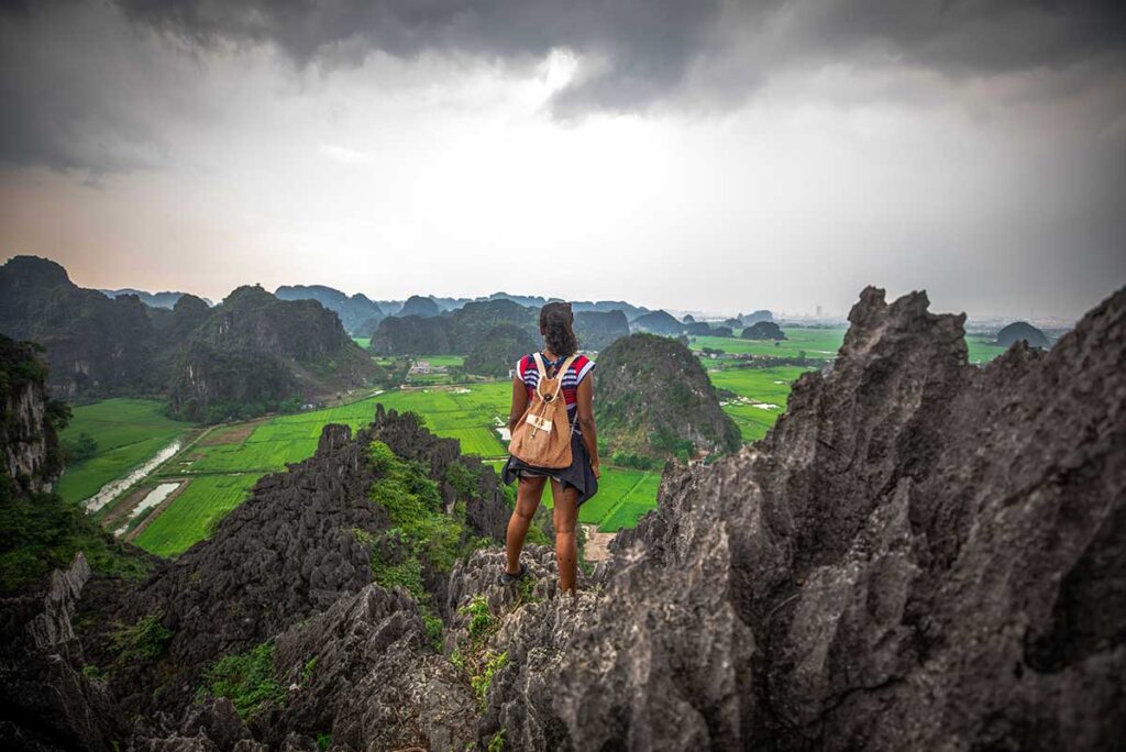
The full climb takes between 20 and 45 minutes depending on fitness. It is short but steep the entire way, and the heat and humidity add to the effort. Most people need to stop a few times. There is no flat ground at the summit, just a narrow ridge with a small standing area right at the edge of the cliff.
The view
The view from the top is the reason people make the effort, and it delivers. Ha Long Bay spreads out below with limestone islands stretching as far as the horizon in every direction. On the opposite side, Ha Long City lines the coast — the coastal road, the bay, the Ferris wheel of Sun World visible in the distance. It is a rare perspective that you cannot get from a cruise, and many people who have done both say the view from Bai Tho Mountain is more impressive.
Early morning offers cooler temperatures, softer light, and occasional mist over the bay that makes the landscape look almost unreal. Sunset is popular for the color it adds to the water and islands, but it means descending in fading light — the upper section of the trail is not somewhere you want to be navigating in the dark. If you go for sunset, start the descent before the sun fully drops.
The poem inscription
Near the summit, the rock face carries the inscription carved by King Le Thanh Tong in 1468. Originally 56 Chinese characters written in eight lines, weathering has reduced it to 35 legible characters today. The poem praises the natural beauty of Ha Long Bay and, according to historians, expresses a wish for peace. In the centuries after, other poets and officials added their own verses to the rock — nine poems in total remain. It is easy to walk past without noticing, but worth taking a moment to look for.
Practical tips and visiting information
Entrance fee: There is no fixed price. Most visitors pay around 100,000 VND per person, but the owner sets the rate herself and it changes. Amounts ranging from 50,000 to 500,000 VND per person have been reported. Bring enough cash to cover the higher end and do not expect to negotiate down significantly.
Best time of day: Early morning is the best option overall — cooler temperatures, better light, and fewer people at the top. If you prefer sunset, factor in enough time to descend safely before dark. Avoid midday in hot weather; the climb is exposed and the heat makes it significantly harder.
Weather: Do not go after rain. The rock scramble at the start becomes dangerously slippery when wet, and mud on the upper sections adds further risk. Check the forecast before heading out.
Footwear: Proper closed shoes are essential. Hiking shoes or sturdy trainers are ideal. Flip flops and sandals are not suitable for any part of this trail.
What to bring: Water is a must — there is nothing available on the trail. Sunscreen and a hat for the exposed sections, insect repellent for the overgrown mid-section where mosquitoes are active. Gloves are not necessary but some people find them useful on the rock scramble.
Fitness level: Be realistic about this. The hike is short but physically demanding, and the initial scramble requires a basic level of agility and upper body strength. It is not suitable for people with vertigo, heart conditions, or limited mobility. Take children only if they are confident and physically capable.
Go with someone: The trail is unmarked, there is no phone signal at the top, and the terrain is uneven throughout. Going alone is not recommended.
Monkeys: A small number of monkeys live on the mountain and are occasionally spotted on the trail. Do not approach or attempt to feed them.
Long Tien Pagoda and Duc Ong Temple
At the base of Bai Tho Mountain, two religious sites are worth a brief visit if you have time before or after the hike.
Long Tien Pagoda, built in 1941, is the largest pagoda in central Ha Long City. It honors both Buddhist deities and a Tran Dynasty general who defended Vietnam’s northern borders, and remains an active place of worship for locals. The architecture reflects the Nguyen Dynasty style and the grounds are peaceful — a decent contrast to the climb above. If you happen to visit during the third lunar month, the Long Tien Festival draws a large local crowd and is one of the more significant spring celebrations in Ha Long.
Duc Ong Temple sits nearby and is dedicated to Tran Quoc Nghien, a son of the famous general Tran Hung Dao who led Vietnam’s resistance against the Mongol Yuan in the 13th century. Local fishermen built the temple to honor his memory, and it remains a sacred site for many Vietnamese visitors. It is small and quiet, shaded by old trees, and worth a few minutes if you are already at the mountain.
Neither site is a reason to visit Ha Long on its own, but both add some context to the area around Bai Tho Mountain and take little extra time.
Is Bai Tho Mountain worth visiting?
For the view alone, yes — but only if you go in knowing what to expect.
The panorama from the summit is genuinely exceptional. It is widely considered the best ground-level vantage point over Ha Long Bay, and people who have also done a bay cruise consistently say the perspective from above is something different entirely. That is not an exaggeration. On a clear morning, the view stretches across thousands of limestone islands and is the kind of thing that stays with you.
The visit itself, however, is not for everyone. The access is unofficial, the trail is unmaintained, and the initial scramble is legitimately demanding. Visitors who go unprepared — wrong shoes, no water, after heavy rain, alone, or without a basic level of fitness — are the ones who have bad experiences here. The reviews that describe it as dangerous are not wrong, but they mostly describe people who went in underestimating what it involves.
If you are reasonably fit, wear the right shoes, pick a dry day, and go with at least one other person, the hike is manageable and the reward at the top is worth every step of it. If any of those conditions do not apply, it is better to skip it rather than push through and regret it halfway up.
One honest note: the access situation — walking through a stranger’s backyard, a portable ladder, a cash fee with no fixed price — can feel strange if you are not expecting it. It is not dangerous in itself, just unconventional. Treat it as part of the experience and it becomes a good story rather than an obstacle.